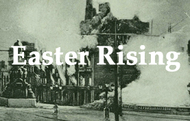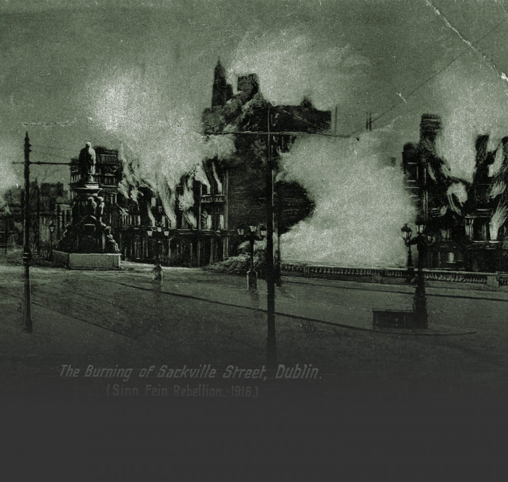
9 August 1922: The Battle for Cork
Landscapes of Counter-Memory
By Joanna Brück and Damian Shiels
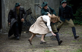
On Wednesday, 9 August 1922, an Irish Free State soldier named Flood was shot by anti-Treaty forces who had taken up positions in the hills overlooking Rochestown and Douglas, hoping to obstruct the advance of the National Army on Cork city.¹ Flood was one of a detachment of troops advancing across a field in a bid to outflank a group of IRA Volunteers positioned at a sharp bend in the road. Emerging through a gate onto the road, he was hit by a burst of IRA machine-gun fire. As Flood lay dying, Frank O’Donoghue, a republican who had fought alongside him in the War of Independence, broke cover, running out to take his hand and to say an Act of Contrition in his ear. This moment epitomises the bitter ironies of the civil war that have made it such a difficult episode in Ireland’s recent history.
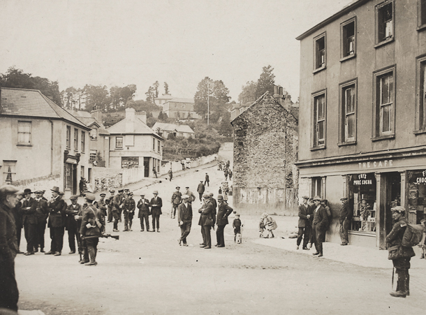
In this essay, we wish to highlight the forgotten landscapes of the civil war. Like other elements of Ireland’s post-1700 heritage, the landscapes of the civil war are afforded no statutory protection. This is compounded by the particular challenges around remembering and coming to terms with this contentious period in Ireland’s recent revolutionary past. Yet, the material residues of the civil war have significant potential to illuminate the details of the conflict. More than this, though, they speak powerfully of the texture of human emotion and experience, not only of those who fought and died, but also of the civilians caught up in the conflict. The sharp bend in the road at which Frank O’Donoghue and his comrades were positioned has now been bypassed, but it survives as a quiet lane with modern housing on either side. The iron gate through which Flood passed is still present. Known locally as the ‘battlefield gate’, its frame is pierced with bullet holes that stand as testament to the ferocity of the fighting that took place here.
The ‘battlefield gate’ signposts the archaeological potential of civil war landscapes, specifically in this case the area between Passage West and Cork city, which witnessed some of the most intensive clashes of the conflict.² Although the docks at Passage West have been significantly reworked since the Free State landings there in the early hours of the morning on Tuesday, 8 August 1922, much of the historic streetscape remains intact. It is little surprise, then, that features such as bullet-impact scars survive in the fabric of some of these buildings. On the wall of the Criterion Bar and its surrounds, the damage caused by bullets fired by National Army troops remains visible. They were created as Free State forces emerged from the docks and returned the fire of republicans positioned on high ground above them. Other buildings tell the opposite side of the story: the houses of Somerville Terrace display the evidence for incoming republican bullets, a reminder of the harassing fire they discharged from across the channel in Carrigaloe, on Great Island.
The heaviest fighting took place in the vicinity of Rochestown on Tuesday and Wednesday, and most casualties in the battle for Cork were recorded in this area.³ Two eye-witness accounts—one by Dr James Lynch, a local doctor who tended the wounded, and another by Fr Michael OFM, a priest in the Capuchin monastery at Rochestown—provide richly textured detail on the events of those days.⁴ Combining these with contemporary newspaper accounts, the second edition Ordnance Survey maps and the 1911 census data, it is possible to identify many of the key sites of the engagement, to assess how the opposing forces moved through the landscape, and crucially to examine the extent to which buildings and other landscape features that appear in accounts of the conflict have survived into the present.
The authors have conducted an initial phase of fieldwork to assess the archaeological survival of the buildings, boundaries and features associated with this 1922 conflict landscape.⁵ Many of these survive today. For example, the road bridge at Rochestown, which was blown up by anti-Treaty troops on Tuesday morning, lies to one side of the modern road; the rebuilt central section remains clearly visible. Many of the buildings occupied and routes followed by both sides through the landscape are still extant. Among them are Dr Lynch’s house, which served as a key National Army position and field hospital during the heaviest fighting, and which is today part of the Garryduff sports centre. The cottage of William and Mary Cronin, where three republican soldiers, famously including Scottish Volunteer Ian ‘Scottie’ McKenzie Kennedy, made a ‘last stand’, also appears extant, though likely much altered.⁶
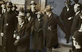
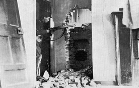
The Cronin cottage and nearby ‘battlefield gate’ were at the vortex of the heaviest fighting of all in Rochestown. Among the most important surviving features in this area are the field boundaries that the republicans used as defensive positions, and from where they laid down intensive machine-gun fire. Some of the National Army men advancing over the exposed ground from the Lynch house towards these positions were First World War veterans, and that day’s experience must have been traumatically reminiscent of the Western Front. Some of the injuries certainly were, as attested to by applications in the Military Service Pensions Collection. Ex-British soldier James Gavigan was struck in the head during the attack, and only ‘lived a short time’ afterwards. When the firing ceased, his Mullingar comrades knelt around his body and ‘prayed for the happy repose of his soul’. Fellow Free Stater James Madden’s section suffered particularly heavy casualties at the hands of the machine guns. Madden was killed instantly when he was ‘hit in the forehead’. On the anti-Treaty side, nineteen-year-old republican Christopher Olden lingered for two days after being struck in the intestines during the Rochestown fighting, before succumbing to shock and hemorrhaging in the South Infirmary.⁷ The engagement had a lasting impact on the civilian population as well, not least the elderly Cronins who ‘screamed and called while the Staters surrounded the cottage’, a building Scottie McKenzie and fellow anti-Treaty Volunteer James Maloney died defending.⁸ A photograph published in the Cork Examiner on 23 August shows the Cronins standing forlornly outside their shattered home holding possessions riddled with bullet holes.
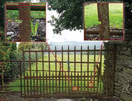
The ‘battlefield gate’, Rochestown, Co. Cork: close-ups display where the frame was pierced by bullets (Image: courtesy of Damian Shiels)
The railway and maritime heritage of the area between Passage West and Cork city is widely known and appreciated among the public today: the old route of the Cork, Blackrock and Passage Railway, for instance, is a popular local walk, while the recently established Passage West Maritime Museum showcases the area’s history. Yet, the momentous events of the civil war that took place here remain underexplored, their memory all but invisible in the contemporary landscape. At Passage West, the only memorial to an incident during the revolutionary years commemorates the death of a member of Cork No.1 Brigade during the War of Independence. Garryduff woods, a public recreation area owned by Coillte, lies at the heart of the battlefield, but there is no signage to indicate the historical significance of the area—indeed no such signage exists anywhere in Passage West or Rochestown. In what is an almost ubiquitous issue with respect to revolutionary-era conflict sites, the landscape features that survive—with the possible exception of the ‘battlefield gate’—have done so by accident rather than design.
Combining archaeological methods with archival evidence, it is possible to address these deficits, and employ the material remains of the past to provide insights into the events and experiences of conflict. The Irish civil war has been marked by forgetfulness—the eliding of a past that has been too painful to remember—but such acts of forgetting have political consequences, for they paper over dissonances in memory and experience in an effort to create a past that is uncontentious. As we approach the centenary of the civil war, it is all the more important to record its fragile and undocumented sites and landscapes and to recognise the damage that can be done to them by modern development.
Engaging with these landscapes can help to make visible the traces of repressed pasts and to ensure that discourse around difficult histories remains in the public sphere. Beyond this, however, the material residues of the past have restorative and redemptive potential. Sites of conflict have an enduring affective presence, foregrounding the humanity and suffering of those caught up in these events. The material remains of the past open spaces for reflection that make possible new dialogues and new ways of seeing the ‘other’. As we approach the centenary and beyond, there is potential for such places to act as pivots around which to recount and come to terms with difficult histories, through practices of meaning-making, recognition and accountability that facilitate social repair in the present.
Extracted from Ireland 1922 edited by Darragh Gannon and Fearghal McGarry and published by the Royal Irish Academy with support from the Department of Tourism, Culture, Arts, Gaeltacht, Sport and Media under the Decade of Centenaries 2012-2023 programme. Click here to view more articles in this series, or click the image below to visit the RIA website for more information.